 Got an email yesterday from someone wanting to hike along the North Fork of the American River. She was asking how to get to the North Fork from Sacramento.
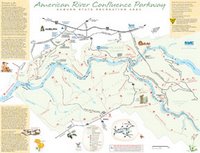
Obviously there are a lot of different trailheads and trails along the North Fork, so I was initially stumped for a response. But then I remembered the wonderful new American River Confluence Parkway Map that Protect American River Canyons (PARC) recently posted. It’s a great introductory guide to the popular trails and flora and fauna of the area around the confluence of the North and Middle Forks of the American River. If you can find your way to Auburn on I-80 or Hwy 49, you can find your way to some short hikes along the Middle and North Forks of the American.
You can view the map online or purchase a copy of the map and brochure for $7.50. Go to the PARC map page for more details. And say “hi” to the river for me, okay?