Maps and General Information
The American River watershed can be found in California, U.S.A. It begins in the heights of the Sierra Nevada just west of Lake Tahoe and travels west, joining the Sacramento River in California’s capitol city of Sacramento. See the watershed map for an overview of the relationship of the different sections of the river to Sacramento, Lake Tahoe, and other landmarks.
Most of the upper stretches of the South Fork of the American River, along with the Rubicon tributary of the Middle Fork, are located within the El Dorado National Forest. Their website has links to fire and aviation, maps, FAQs, and permit information for the Forest. Most of the North Fork watershed and the rest of the Middle Fork are located within the Tahoe National Forest, whose website is also a great resource.
We recommend the printed maps and guidebooks published by PARC (Protect American River Canyons). Many of their materials cover the Auburn State Recreation Area (ASRA), which encompasses much of the North and Middle Fork watersheds. You’ll find river maps, hiking trails, nature guides, and the comprehensive An Insider’s Guide to the North, Middle and South Forks of the American River and Canyons, now in its 3rd edition.
El Dorado County’s South Fork American River Whitewater Recreation Program has a page with river access maps.
As of June, 2017, we’ve provided downloads of some maps below, but things do change. So if you require the most up-to-date access information, we recommend checking with the source.

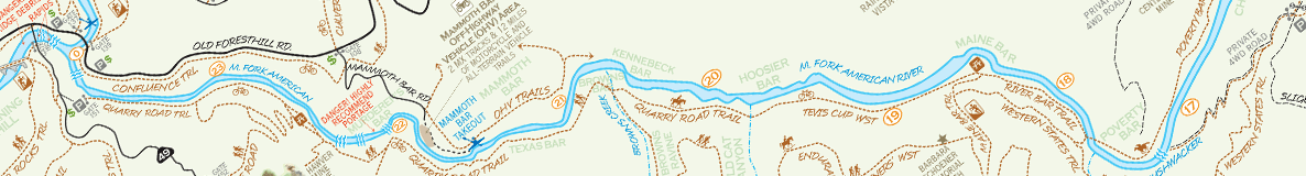
Tahoe National Forest
Overview of the Tahoe National Forest includes the North Fork and Middle Fork watersheds. View larger. Download PDF.

El Dorado National Forest
Includes the South Fork watershed and the Rubicon, a tributary of the Middle Fork. View larger. Download PDF.

ASRA
PARC’s detailed map/guide of the North and Middle Forks. View p. 1. View p. 2. Purchase printed copy. Download PDF.

South Fork Access Map (2006)
Roads, rapids, and access for the South Fork, from El Dorado County. View Upper Run (Chili Bar). View Lower Run (Gorge). Download PDF.

South Fork Access Map (2000)
Roads and rapids for the South Fork, from El Dorado County. Nice river detail, but access info not up-to-date. View larger. Download PDF.


Whitewater Guides
 Online guides:
- Bill Tuthill has been building his California Creeks website for 20 years. Excellent river descriptions and photographs of all the Class II-IV American River runs, told from the perspective of a seasoned and competent IK paddler.
- Darin McQuoid presents the view of a Class IV-V+ kayaker. Trip descriptions of the upper reaches of the American forks and its tributaries, including the North Fork of the North Fork, the Rubicon, and the Silver Fork of the South Fork, liberally illustrated with fabulous photographs. (Photo right: Jonas Grünwald running the North Fork of the Middle Fork, ©Darin McQuoid.)
- This California Whitewater site has basic information about the most commonly rafted runs on the American, with photos.
In addition to the PARC guide referenced above, there are several printed guidebooks aimed at paddlers. Unfortunately none have been recently published, but they are still useful and make for great reading. You can find used copies on Amazon and elsewhere:
- A Guide to the Best Whitewater in the State of California, by Lars Holbek and Chuck Stanley. Written in 1984; revised and reprinted in 1988 and 1998. Great stories of classic first descents, with lots of useful logistical information. Not practical for novices but a good read nonetheless.
- California Whitewater: A Guide to the Rivers, by Jim Cassady and Fryar Calhoun. Covers all the popular rafting and kayaking runs, with emphasis on Class II-IV. A solid guidebook, last reprinted in 1995. Available from Cassady’s company for $19.95.
- Western Whitewater from the Rockies to the Pacific: A River Guide for Raft, Kayak, and Canoe, by Jim Cassady, Bill Cross, and Fryar Calhoun. Expands on Cassady & Calhoun’s previous work, last reprinted in 1994.
Other Sources
Main Stem of the American River: Interactive map from the American River Parkway Association.
Many of the rafting outfitters have river maps on their websites.
If you have maps or other information to share, please contact us.